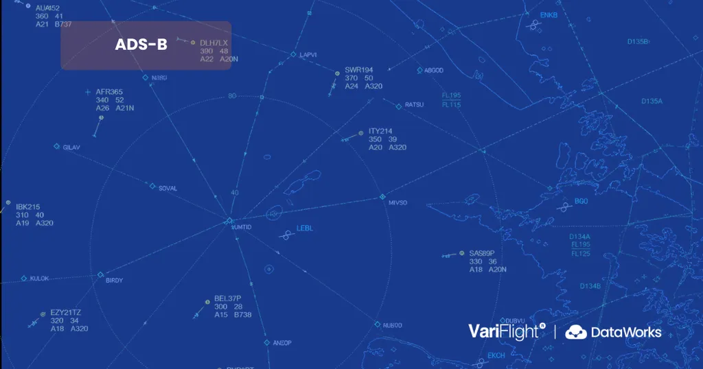
When you open a flight tracking website, an aircraft icon may appear to move smoothly across the map in near real time.
It can look as though the platform is receiving a continuous location signal directly from the aircraft. In reality, modern flight tracking involves a much more complex data chain.
The aircraft must first determine its own position. It then broadcasts information that can be received by ground stations or satellites. The raw messages must be decoded, checked, connected into a continuous track and matched with a commercial flight.
Additional operational data is then required to determine whether the flight is delayed, when it is expected to arrive, whether it is circling or diverting, and which airport or airline systems should be notified.
Among the technologies used in this process, ADS-B has become one of the most important sources of aircraft position and movement data.
What Is Flight Tracking?
Flight tracking is the process of monitoring an aircraft’s position and movement throughout its journey.
A modern flight tracking system may process information including:
- Latitude and longitude
- Altitude
- Ground speed
- Direction of travel
- Vertical speed
- Aircraft identity
- Flight path
- Departure and arrival airports
- Estimated arrival time
- Take-off, landing, diversion and return events
However, aircraft tracking and flight status are not the same thing.
An aircraft signal may show where the aircraft is, how high it is flying and how fast it is moving. It does not automatically identify every operational detail associated with the commercial flight.
For example, position data alone may not confirm:
- Whether the flight is delayed
- Whether the aircraft has left the gate
- Which commercial flight number it is operating
- Whether it has been diverted
- When it will reach the arrival stand
- Which terminal or baggage belt will be used
To produce a complete flight record, aircraft surveillance data must be combined with schedules, airport information, airline operations data and predictive algorithms.
What Role Does Radar Play in Flight Tracking?
Radar remains a fundamental part of air traffic surveillance, particularly for certified air traffic control systems.
Primary surveillance radar sends radio signals into the airspace and detects energy reflected by an aircraft. It can identify the direction and approximate distance of a target without requiring the aircraft to transmit its own position.
Secondary surveillance radar works differently. It interrogates the aircraft’s transponder, which responds with information such as identity codes and pressure altitude.
Radar provides valuable independent surveillance, but large radar installations are expensive to build and maintain. Their coverage can also be affected by terrain, line of sight and the location of the radar facility.
ADS-B ground receivers are generally smaller, more flexible to deploy and better suited to creating distributed monitoring networks.
Radar and ADS-B should not be viewed as complete substitutes for one another. Professional aviation surveillance systems may combine radar, ADS-B and other data sources according to operational and safety requirements.
For commercial flight tracking platforms, however, ADS-B is often the central source of frequent aircraft position updates.
What Is ADS-B?
ADS-B stands for:
Automatic Dependent Surveillance–Broadcast
Each part of the name describes how the technology works.
- Automatic: The aircraft transmits information automatically without waiting for an individual request for every message.
- Dependent: The reported position depends mainly on the aircraft’s onboard navigation system.
- Surveillance: The information is used to monitor the aircraft’s position and movement.
- Broadcast: The aircraft sends the information openly to compatible receivers within range.
An ADS-B message may contain:
- A unique 24-bit ICAO aircraft address
- Flight identification or call sign
- Latitude and longitude
- Pressure or geometric altitude
- Ground speed
- Track direction
- Vertical speed
- Emergency status
- Data quality indicators
Commercial aircraft commonly transmit ADS-B messages using the 1090 MHz Extended Squitter data link, also known as 1090ES.
The aircraft may broadcast updated information roughly once per second. However, the update frequency visible to a user can also depend on receiver coverage, data transmission, processing time and the display refresh rate of the application.
How Does ADS-B Flight Tracking Work?
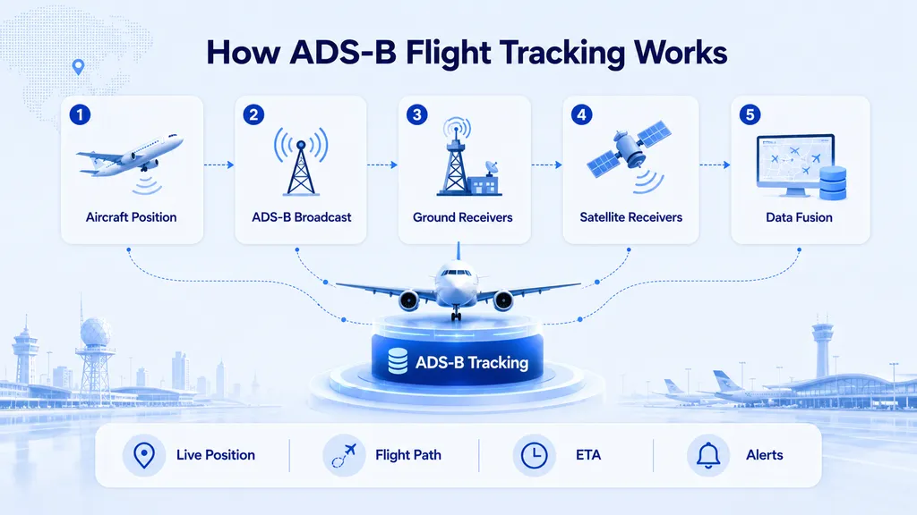
A raw ADS-B signal must pass through several stages before it becomes a moving aircraft icon on a website or application.
1. The Aircraft Determines Its Position
The aircraft first calculates its position using its onboard navigation systems.
These systems may use global navigation satellite systems such as:
- GPS
- Galileo
- BeiDou
- Other onboard navigation sensors
Navigation satellites help the aircraft determine where it is.
This does not necessarily mean that the navigation satellite is directly tracking the aircraft. The aircraft receives navigation signals, calculates its position and then broadcasts that calculated position through ADS-B.
2. The Aircraft Creates an ADS-B Message
The aircraft’s avionics combine the calculated position with other flight parameters.
Depending on the equipment and message type, the broadcast may include:
- Aircraft identity
- Current position
- Altitude
- Ground speed
- Direction of movement
- Rate of climb or descent
- Transponder and emergency status
- Position integrity indicators
These fields allow a receiving system to understand both where the aircraft is and how it is moving.
3. The Aircraft Broadcasts the Message
The aircraft automatically transmits ADS-B messages at regular intervals.
Unlike traditional secondary radar, ADS-B does not require a ground radar station to interrogate the aircraft before each transmission.
The aircraft broadcasts the information so that compatible systems within reception range can collect it.
These receivers may include:
- Ground-based ADS-B stations
- Airport surveillance networks
- Other equipped aircraft
- Satellite-based ADS-B receivers
4. Ground Stations Receive the Signal
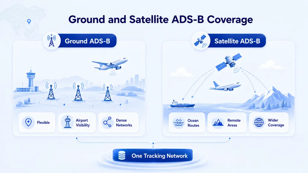
Across populated areas and major flight corridors, ADS-B signals are commonly received by terrestrial stations.
A ground receiver records the aircraft message together with information such as:
- Reception time
- Receiver location
- Signal strength
- Message type
- Aircraft address
The receiver then sends the data to a processing platform or data centre.
The effectiveness of ground-based ADS-B depends heavily on line of sight.
At cruising altitude, an aircraft’s signal may be received from a considerable distance. As the aircraft descends, mountains, buildings and the curvature of the Earth may begin to block the signal.
This is why a dense receiver network is important for reliable coverage.
5. Satellite Receivers Extend Coverage
Ground receivers are difficult to install across oceans, high mountains, polar regions and remote areas.
Space-based ADS-B addresses this limitation by placing compatible ADS-B receivers on satellites, usually in low Earth orbit.
The aircraft continues to broadcast ADS-B messages in the normal way. The difference is that the signal is received from above rather than by a terrestrial antenna.
The satellite forwards the observation to a ground processing network.
This can improve visibility over:
- Oceans
- Mountain regions
- Deserts
- Polar routes
- Remote and sparsely populated areas
Satellite navigation and satellite ADS-B reception are therefore different concepts.
A navigation satellite helps the aircraft calculate its location. A space-based ADS-B receiver collects the location message transmitted by the aircraft.
VariFlight has also worked with COMAC on satellite-based ADS-B receiving technology to improve aircraft monitoring over mountains, oceans and other areas where ground coverage is limited.
Space-based ADS-B can significantly extend geographic coverage, but it does not guarantee that every aircraft can be tracked continuously.
Coverage still depends on:
- Compatible aircraft equipment
- Normal aircraft transmissions
- Signal reception conditions
- Satellite network availability
- Data delivery arrangements
- Processing and quality-control systems
6. Raw Messages Are Decoded
After a ground station or satellite receives an ADS-B transmission, the raw message must be decoded.
The processing system extracts structured fields such as:
- ICAO aircraft address
- Call sign
- Coordinates
- Altitude
- Speed
- Direction
- Vertical movement
- Emergency status
A single decoded message is not enough to create a reliable flight track.
Tracking platforms receive large volumes of messages from many aircraft and receivers. These observations must be organised and validated before they can be displayed or used operationally.
7. The Data Is Cleaned and Validated
ADS-B platforms may receive duplicate observations of the same aircraft from several receivers.
They may also encounter:
- Missing fields
- Invalid coordinates
- Sudden position jumps
- Impossible speed changes
- Unusual altitude changes
- Delayed messages
- Temporary reception gaps
- Incorrect aircraft configuration
The platform therefore applies quality-control rules.
It may compare the new observation with:
- The aircraft’s previous position
- Expected speed and direction
- Historical aircraft movement
- Reports from other receivers
- Other surveillance or operational data
Messages that appear inconsistent may be filtered, corrected or assigned a lower confidence level.
This validation process is one reason why two flight tracking platforms may show slightly different results for the same aircraft.
8. Position Reports Become a Flight Track
Once the messages have been processed, the system connects successive observations into a continuous aircraft track.
The flight path displayed on a map is therefore not a single signal.
It is a sequence of position reports that have been:
- Time-ordered
- Deduplicated
- Validated
- Associated with the same aircraft
- Converted into a continuous trajectory
If reception is temporarily interrupted, some platforms may estimate a short section of the track using the last known position, speed and direction.
As a result, a smoothly moving aircraft icon does not always mean that every displayed position came from a newly received ADS-B message.
9. The Aircraft Must Be Matched to a Commercial Flight
ADS-B primarily identifies and tracks the physical aircraft.
Passengers and travel applications, however, usually search by commercial flight number.
The system must therefore determine which scheduled flight the aircraft is operating.
Flight matching may use:
- ICAO aircraft address
- Registration number
- Call sign
- Airline
- Departure airport
- Arrival airport
- Scheduled departure time
- Actual flight direction
- Aircraft rotation history
- Previous and following flights
- Schedule changes
This step can be difficult when:
- The airline changes the operating aircraft
- A flight is heavily delayed
- The call sign differs from the public flight number
- The aircraft operates several sectors in one day
- A flight is diverted or returns to its departure airport
A platform can receive an accurate aircraft position but still display the wrong flight if the identity-matching process is incorrect.
10. ADS-B Data Is Combined with Other Aviation Data
ADS-B mainly answers the question:
Where is the aircraft, and how is it moving?
A complete flight data service must answer additional questions:
- Which flight is it?
- Is it operating on schedule?
- Has it departed?
- When will it arrive?
- Is it circling, diverting or returning?
- Which airport facilities will be needed?
To answer these questions, ADS-B data may be combined with:
- Airline schedules
- Airport operational data
- Actual departure and arrival events
- Weather information
- Air traffic flow information
- Historical flight records
- Terminal and gate information
- Delay and cancellation data
- Predictive models
This process is known as data fusion.
The final result is not simply a decoded ADS-B message. It is a structured operational flight record that can be delivered through websites, applications, airport systems or aviation data APIs.
How VariFlight Uses ADS-B Data
Following the development of China’s national ADS-B implementation planning, VariFlight began building its ADS-B system in 2015.
The system was designed to receive aircraft broadcast data, combine it with VariFlight flight status information and apply proprietary processing algorithms.
This allows the platform to monitor and display:
- Aircraft position
- Flight trajectory
- Altitude and speed
- Flight progress
- Estimated arrival time
- Abnormal movement
- Special transponder status
VariFlight’s ADS-B monitoring network currently tracks more than 6,600 aircraft each day.
This figure describes the scale of aircraft monitored through the ADS-B network. It is separate from the wider volume of flight data processed by the VariFlight platform.
When ADS-B observations are combined with flight schedules, airport operational data and other information sources, the wider VariFlight platform processes data for more than 170,000 flights daily.
These two figures represent different parts of the data chain:
- 6,600+ aircraft per day: aircraft monitored through the ADS-B network
- 170,000+ flights per day: flight records processed across the broader VariFlight data platform
This distinction is important because not every flight record is created solely from ADS-B data.
Flight schedules, airport information, airline updates and other sources also contribute to the wider flight data coverage.
How Ground-Based ADS-B Networks Improve Coverage
A single receiver can only monitor aircraft within its effective reception area.
To expand coverage, flight tracking providers build or connect networks of ADS-B ground stations.
A distributed network can help:
- Extend monitored airspace
- Improve coverage near airports
- Reduce the impact of a single receiver failure
- Collect the same aircraft signal from several locations
- Improve trajectory continuity
- Support cross-checking and quality control
VariFlight has deployed ADS-B ground receiving stations across China to monitor aircraft equipped with compatible ADS-B systems.
The company has also continued to expand international receiver coverage and external data connections to improve global aircraft monitoring.
However, coverage should not be described as completely without gaps.
Reception can still be affected by:
- Aircraft altitude
- Terrain
- Receiver density
- Local interference
- Equipment availability
- Transmission failures
- Data access and processing conditions
How ADS-B Supports Estimated Arrival Time
Knowing an aircraft’s current location does not automatically provide an accurate estimated time of arrival.
A basic calculation might divide the remaining distance by the current speed. In real operations, this is often insufficient.
An aircraft may:
- Change speed
- Follow a non-direct arrival route
- Avoid weather
- Enter a holding pattern
- Circle before landing
- Be redirected by air traffic control
- Approach the airport from a different direction
A more accurate ETA model may consider:
- Current position
- Altitude
- Ground speed
- Flight direction
- Remaining route
- Airport approach patterns
- Historical flight duration
- Weather
- Airport congestion
- Air traffic restrictions
- Previous updates to the flight path
VariFlight combines ADS-B observations with flight status data and predictive algorithms to calculate and revise estimated arrival times.
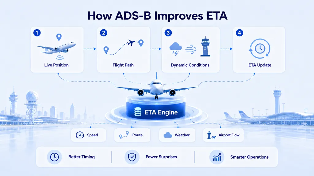
According to historical system performance data provided by VariFlight, for approximately 80% to 90% of flights, the ETA calculated 30 minutes before arrival could be kept within three minutes of the actual arrival time.
When an aircraft circles, diverts or follows an abnormal route, the ETA can be recalculated as new ADS-B observations become available.
Because this performance figure depends on the sample, period, airport and operational conditions, it should be published together with an appropriate methodology or measurement scope when used as a formal commercial claim.
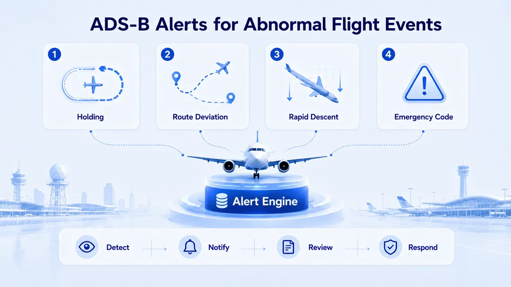
How ADS-B Can Detect Abnormal Flight Behaviour
Continuous ADS-B tracking can help identify movements that differ from normal flight patterns.
Examples may include:
- Repeated circling
- Rapid altitude increase
- Rapid altitude decrease
- Significant deviation from the expected route
- Unusual speed changes
- Return to the departure airport
- Movement towards an unplanned destination
- Extended holding near an airport
A monitoring platform can define thresholds for different types of abnormal behaviour.
When the aircraft data crosses one of these thresholds, the system may generate an operational alert.
This can help airports, airlines and other organisations identify a situation quickly and begin further investigation.
An unusual trajectory does not necessarily indicate an emergency.
Circling may result from normal holding procedures. A route deviation may be caused by weather, restricted airspace or traffic management.
ADS-B alerts should therefore be treated as situational indicators rather than final explanations of an event.
Monitoring Special Transponder Codes
Aircraft transponders can use internationally recognised codes to communicate special conditions.
Common examples include:
- 7500: Unlawful interference or hijacking
- 7600: Radio communication failure
- 7700: General emergency
An ADS-B monitoring system can identify the corresponding emergency status broadcast by the aircraft.
VariFlight’s ADS-B system can use predefined rules to:
- Mark the affected aircraft
- Trigger a system alert
- Notify relevant users
- Preserve the corresponding trajectory and status data
- Support further operational review
Special-code monitoring can shorten the time required to identify a possible abnormal situation.
However, the code should still be verified against other operational and communication information, as incorrect selection, short-term changes or equipment issues can occur.
How ADS-B Data Supports Aviation Operations
ADS-B data has uses far beyond the aircraft icons shown on consumer flight tracking maps.
Air Traffic and Airspace Monitoring
ADS-B can supplement traditional surveillance infrastructure and improve visibility in areas where radar deployment is difficult or expensive.
Airport Operations
Airports can use aircraft position and ETA information to support the allocation of:
- Parking stands
- Boarding bridges
- Ground handling staff
- Baggage resources
- Service vehicles
- Arrival support teams
Airline Operations
Airlines can monitor:
- Fleet position
- Flight progress
- Circling and holding
- Diversions
- Returns
- Estimated arrival times
- Aircraft rotations
Airport Collaborative Decision-Making
When ADS-B is combined with airport milestone data, schedules and ground operations information, it can support Airport Collaborative Decision-Making, or A-CDM.
This gives airports, airlines and service providers a more consistent view of the same flight.
Intelligent Flight Alerts
Position, altitude, speed and trajectory changes can be used to support:
- Arrival alerts
- Abnormal-track alerts
- Diversion detection
- Return detection
- Landing and departure event recognition
Aviation Data Analysis
Historical ADS-B trajectories can support:
- Route analysis
- Airport traffic studies
- Aircraft utilisation analysis
- Flight path replay
- Airspace optimisation
- Operational performance evaluation
Why Does an Aircraft Sometimes Disappear from a Tracker?
ADS-B messages may be broadcast frequently, but they cannot always be received continuously.
An aircraft may temporarily disappear because:
- It enters an area with limited receiver coverage
- It descends behind terrain or buildings
- It is flying over an ocean or remote region
- Its onboard equipment is not broadcasting normally
- A receiver or transmission network is interrupted
- The platform filters a low-quality observation
- The aircraft-to-flight association changes
- The application uses a slower display refresh rate
Temporary disappearance does not necessarily mean that the aircraft itself has stopped transmitting or that a safety incident has occurred.
It may simply mean that the flight tracking platform has not received a recent, reliable observation.
Radar vs. Ground-Based ADS-B vs. Space-Based ADS-B
| Technology | How it works | Main advantages | Main limitations |
|---|---|---|---|
| Radar | A ground installation detects reflected signals or interrogates an aircraft transponder | Independent surveillance and established use in air traffic control | High infrastructure cost and coverage limits related to terrain and location |
| Ground-based ADS-B | Ground stations receive position and movement data broadcast by the aircraft | Frequent updates, rich data fields and flexible receiver deployment | Depends on aircraft equipment, receiver networks and line of sight |
| Space-based ADS-B | Satellite receivers collect ADS-B signals broadcast by the aircraft | Extends coverage over oceans and remote regions | Depends on satellite service, aircraft transmissions and data processing |
The quality of a modern flight tracking system does not depend on choosing only one technology.
It depends on combining appropriate surveillance sources and converting them into consistent, useful flight information.
How Should Flight Tracking Accuracy Be Measured?
A smooth aircraft icon is not enough to demonstrate tracking quality.
Accuracy should be assessed across several dimensions.
Position Accuracy
How closely does the displayed location match the aircraft’s actual position?
Data Freshness
How much time passes between the aircraft broadcast and the delivery of the information to the user?
Coverage Continuity
Can the aircraft be observed during departure, cruise, remote segments and arrival?
Aircraft Identity Accuracy
Has the signal been matched to the correct physical aircraft?
Flight Matching Accuracy
Has the aircraft been associated with the correct commercial flight number and route?
ETA Accuracy
Does the estimated arrival time update correctly when the aircraft changes speed, route or operating conditions?
Operational Completeness
Does the platform also provide the schedule, delay, cancellation, diversion, terminal, gate and actual arrival information required by the user?
A platform may provide precise coordinates but match them to the wrong flight.
Another platform may identify the correct flight but have less frequent position updates in a remote region.
Reliable flight tracking therefore depends on receiver coverage, message quality, identity matching, operational data and data-fusion capability.
Frequently Asked Questions
Is ADS-B the same as radar?
No.
Radar detects or interrogates aircraft from a ground installation. ADS-B allows the aircraft to broadcast position and movement information calculated by its onboard systems.
Does satellite navigation mean a satellite is directly tracking the aircraft?
Not necessarily.
Navigation satellites help the aircraft determine its own position. The aircraft then broadcasts that position, which may be received by a ground station or a satellite-based ADS-B receiver.
How often does ADS-B update?
Aircraft may broadcast ADS-B information roughly . The update rate visible to the user can be slower because of reception, transmission, processing and display systems.
Can ADS-B identify whether a flight is delayed?
Not by itself.
ADS-B primarily provides aircraft position and movement information. Delay detection requires comparison with schedules, airport events and other operational data.
Why do different flight tracking platforms show different results?
Platforms may use different receiver networks, satellite data sources, processing delays, filtering rules, aircraft-matching methods and flight-status definitions.
Can ADS-B track every aircraft worldwide?
No single ADS-B network should be assumed to track every aircraft continuously.
Coverage depends on aircraft equipment, ground and satellite receiver networks, signal quality, data access and processing capability.
What is the difference between tracking an aircraft and tracking a flight?
Aircraft tracking follows the physical aircraft and its movement.
Flight tracking connects that aircraft with a scheduled commercial service, including its flight number, route, times and operational status.
Conclusion
Modern flight tracking is not simply a process of placing one aircraft coordinate on a map.
The aircraft first calculates its own position and broadcasts identity, altitude, speed, direction and other information through ADS-B.
Ground stations or satellite receivers collect the signal. The data platform then performs:
- Message decoding
- Quality control
- Track generation
- Aircraft identification
- Flight matching
- ETA calculation
- Abnormal-movement detection
- Multi-source data fusion
Only after these stages does the raw aircraft signal become a useful flight record.
VariFlight’s ADS-B network currently monitors more than 6,600 aircraft each day. When these observations are combined with schedules, airport operations data and other aviation sources, the wider VariFlight platform processes more than 170,000 flight records daily.
The aircraft icon moving across a map is only the visible output.
Behind it is a larger aviation data system that transforms aircraft broadcasts into reliable positions, trajectories, arrival predictions and operational flight information.